Report Cautions: Millions of U.S. Homes Face Elevated Hurricane Risk Despite Expectations for a Quieter 2026 Season
Guidewire HazardHub analysis highlights concentrated coastal exposure and rapid storm intensification trends

Press Release Disclaimer: This is a press release distributed through the XPR Media network. It has not been independently verified by our newsroom.


As the 2026 Atlantic hurricane season begins, early forecasts indicate a near-average or potentially quieter season overall. But new analysis from Guidewire (NYSE: GWRE) suggests that lower storm totals may no longer provide a complete picture of catastrophe exposure as property values rise and population growth and coastal development continue to concentrate risk in vulnerable U.S. regions.
This press release features multimedia. View the full release here: https://www.businesswire.com/news/home/20260729293424/en/
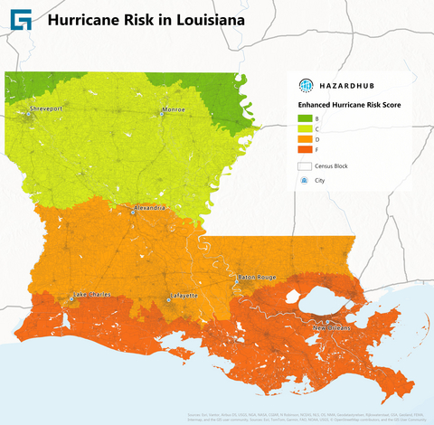
Hurricane risk in Louisiana based on HazardHub enhanced hurricane risk scores.
The P&C insurance industry is increasingly shifting from broad regional catastrophe assumptions toward more granular, local, and property-level risk intelligence as insurers evaluate where storms make landfall, how quickly they intensify, and how much exposure is concentrated along vulnerable coastlines.
Guidewire HazardHub analysis identified more than 3.4 million homes in Florida, more than 1 million homes in Louisiana, and more than 800,000 homes in Texas at elevated combined hurricane wind and storm-surge risk, highlighting how catastrophe exposure remains heavily concentrated along vulnerable Gulf and Southeast coastlines.
The 2025 season demonstrated that storm activity in the Atlantic basin does not always equal U.S. landfalls. Last year brought three Category 5 storms, one of the highest totals on record, yet only one made landfall at Category 5 intensity, striking Jamaica’s southwestern coast rather than a major metropolitan area.
2026 Outlook Features Fewer Storms But No Less Risk
NOAA’s early outlook points to a near-average or slightly below-average Atlantic hurricane season. However, HazardHub experts caution that lower seasonal aggregates do not automatically reduce actual catastrophe exposure for coastal communities or localized insurance portfolios.
“Seasonal forecasts provide an important macro view, but they cannot predict where storms will make landfall or how quickly they may intensify near vulnerable coastal regions,” said Chris Folkman, Vice President of HazardHub, Guidewire. “That uncertainty, combined with concentrated coastal exposure, is why insurers are increasingly focused on granular, property-level catastrophe intelligence.”
Researchers continue to monitor a growing trend of storms intensifying more rapidly, with a larger share reaching Category 3 or higher. Warm sea surface temperatures in the Atlantic and Gulf may trigger rapid intensification just before landfall, leaving less time for preparation or evacuation.
Top 10 States at Risk of Hurricane and Storm Surge Impacts
Hurricane and storm-surge exposure remains heavily concentrated along the Gulf Coast and in the Southeast states. This year, HazardHub combined hurricane wind risk and storm-surge exposure into a unified analysis designed to better reflect the complex drivers of modern catastrophe losses. To identify where exposure is most acute, Guidewire analyzed the percentage of residential properties receiving an “F” grade for hurricane risk and a “D” or “F” grade for storm surge using the HazardHub Hurricane Risk Score. These geospatial risk models consider everything from historical storm tracks and wind exposure to granular, property-level vulnerability.
10 Highest-Risk States
Based on HazardHub’s combined analysis of hurricane wind exposure and storm-surge vulnerability, the states with the highest concentration of elevated hurricane and storm-surge risk, ranked from highest to lowest, are Florida, Louisiana, Texas, South Carolina, North Carolina, Georgia, Alabama, Mississippi, New York, and New Jersey.
The analysis reflects growing industry concern that storm surge, rapid storm intensification near landfall, and concentrated coastal exposure are becoming increasingly important drivers of catastrophe losses.
While wind speeds often dominate headlines, storm surge and flooding frequently drive the largest insured and economic losses during hurricanes. This protection gap remains a critical exposure vulnerability for the market, with only about 4% of homeowners nationwide carrying flood insurance.
Regional Risk Breakdown
Florida Holds the Most Exposure
Managing coastal exposure in Florida requires balancing two distinct threats. The Gulf Coast faces severe storm-surge vulnerability, while major metro hubs like Miami and Tampa continue to concentrate large amounts of property value in hurricane-prone areas. HazardHub analysis identified more than 3.4 million Florida homes at elevated combined hurricane wind and storm-surge risk, representing roughly 35% of the state’s housing stock. That exposure is amplified by Florida’s coastal development patterns, with roughly 76% of the state’s population living in coastal counties and communities concentrated along the Atlantic and Gulf coasts.
“Florida continues to represent the largest aggregation of hurricane risk in the U.S., both in terms of property values and population exposure,” continued Folkman. “That concentration creates enormous challenges not only for homeowners and communities, but also for insurers working to maintain affordability, resilience, and long-term market stability in catastrophe-prone regions.”
The Gulf Coast Faces Storm Surge and Sudden Intensification Risk
Texas and Louisiana rank among the three highest-risk states for combined hurricane surge and intensification. The combination of low-lying geography and warm Gulf waters makes this region particularly vulnerable.
- Louisiana: Louisiana had one of the nation’s highest concentrations of combined hurricane and storm-surge exposure in a HazardHub analysis, with more than 50% of homes classified as high risk (compared to approximately 7% in Texas, another high-risk state). Louisiana’s low-lying coastal geography, including extensive wetlands, marshes, bayous, swamps, and vulnerable coastal plains, leaves many populated southern regions highly exposed to storm surge, inland flooding, and compounding wind-and-water losses from a single event.
- Texas: HazardHub analysis identified more than 800,000 homes in Texas at elevated combined hurricane wind and storm-surge risk, representing roughly 7% of the state’s housing stock. Storm surge exposure remains a major driver of catastrophe risk along vulnerable Gulf Coast corridors, where rapid coastal development continues to increase total exposure in hurricane-prone shoreline regions.
Southeast Atlantic: Carolinas
- North Carolina and South Carolina remain perennial targets for landfalls. Insurers in these states face the combined challenge of expanding coastal exposure and a significant risk of severe inland flooding from heavy rainfall.
Northeast: New York and New Jersey
- New York and New Jersey complete the top 10. While major hits are less frequent here, historical events have shown that when a storm does hit, aging infrastructure, dense populations, and high property values create a high-risk environment for severe losses.
The Shift to Property-Level Risk Intelligence
As weather patterns become more volatile, the P&C insurance industry is moving beyond broad regional assumptions toward granular, location-specific data. HazardHub delivers this precision with:
- Property-level hurricane and storm surge risk scores
- Localized flood zoning and proximity to high-risk areas
- High-fidelity data on distance to coastlines, waterways, and beaches
- Coastal construction line zoning and windborne debris hazards
- Insights into evolving climate and weather patterns
“Catastrophe risk is becoming increasingly measurable and better understood at the property level,” Folkman added. “By pairing high-resolution data with machine learning, underwriters can move beyond broad regional assumptions and evaluate catastrophe exposure structure by structure. This elevates the entire P&C ecosystem: policyholders are rewarded for mitigating risk, insurers gain greater pricing precision and portfolio visibility, and regulators benefit from improved market transparency and stability.”
About Guidewire HazardHub
HazardHub is the industry’s most comprehensive property risk intelligence platform, delivering 50+ predictive peril scores and 1,200+ individual risk factors for every address. Natively embedded into insurance workflows, HazardHub enables insurers to automate underwriting, match rate-to-risk, and manage portfolios effectively. For more information, visit www.hazardhub.com.
About Guidewire Software
Guidewire is the platform P&C insurers trust to engage, innovate, and grow efficiently. More than 570 insurers in 43 countries, from new ventures to the largest and most complex in the world, rely on Guidewire products. With core systems leveraging data and analytics, digital, and artificial intelligence, Guidewire defines cloud platform excellence for P&C insurers.
We are proud of our unparalleled implementation record, with 1,700+ successful projects supported by the industry’s largest R&D team and SI partner ecosystem. Our marketplace represents the largest partner community in P&C, where customers can access hundreds of applications to accelerate integration, localization, and innovation.
For more information, please visit www.guidewire.com and follow us on X and LinkedIn.
View source version on businesswire.com: https://www.businesswire.com/news/home/20260729293424/en/
Media gallery